
Notes from Harney County Library
Written by the staff
|
|
 RSS Feed
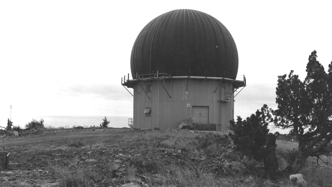 The crumbling remains of a once bustling component of America’s National Air Defense Command system perches on the skyline from a mile-high butte overlooking the cities of Burns and Hines in Oregon’s southeastern corner. Following its closure and abandonment in 1970 after fifteen years of service, this former military installation has been a curiosity to visitors and area residents who only know the site as an eerie remnant from the Cold War era and a heavily vandalized teen hangout.
In an effort to capture the fast-disappearing knowledge of this fascinating chapter in Harney County history, the Harney County Historical Society, in conjunction with the Claire McGill Luce Western History Room at the Harney County Library and the Harney County Chamber of Commerce invites the public to a roundtable community discussion of the 634th Radar Squadron Burns Air Force Station, colloquially known as the Radar Base. Former military personnel, civilian employees, and families are encouraged to join us April 5th at 6 p.m. in the Chamber of Commerce meeting room to share recollections, photographs, or other memorabilia of their experiences associated with the Radar Base. Several local community members who were stationed at the base for a time will begin the discussion by recounting their own experiences. Seventy years ago, in April 1954, construction began on the 31-acre military facility atop Burns Butte that would house the 634th Aircraft Control and Warning Squadron tasked with operating and maintaining search radar sets and height-finder radars. Distinctive rubberized “bubbles” protected the delicate radar electronics from the harsh environment atop the butte. The Burns installation was one of many radar sites and “gap fillers” along a Pacific coast route known as the “Pine Tree Line” –part of the first coordinated system for early detection of a Soviet bomber attack on North America. Rapidly evolving jet and missile technology led to modifications in most of these early detection systems which then joined the Semi-Automatic Ground Environment (SAGE) defense system. The Burns Radar Base was planned as a small community within itself, having many of the same facilities found in any town: housing, cafeteria style dining hall, independent water supply, recreation room and sporting equipment, mail room, etc. in addition to twenty Quonset barracks buildings, an officer’s quarters, two supply houses, two warehouses, well house and a headquarters building. In June 1955, an advance group consisting of a commander and eight men arrived at the site, followed by upwards of 70 enlisted men and their families. At the time of closing in 1970, the base supported twenty civilian employees and 106 Air Force officers and enlisted personnel. The roundtable event is free and open to the public. For more information, contact the Harney County Historical Society. Phone: 541.573.5618 Email: [email protected] Learn more about the history of the Burns Radar Base in the files at the Claire McGill Luce Western History Room and through our online digital archives.
1 Comment
William D. Snell - formerly Captain USAF
5/12/2024 04:31:24 pm
Thank you for your fine article; many men served at Burns Air Force Station, waiting to warn of an attack that (thankfully) never came. As service men we were fortunate to be welcomed by the town of Burns; many positive memories. Leave a Reply. |
Authors
Authored by the staff at Harney County Library! Archives
March 2024
Categories
All
|